
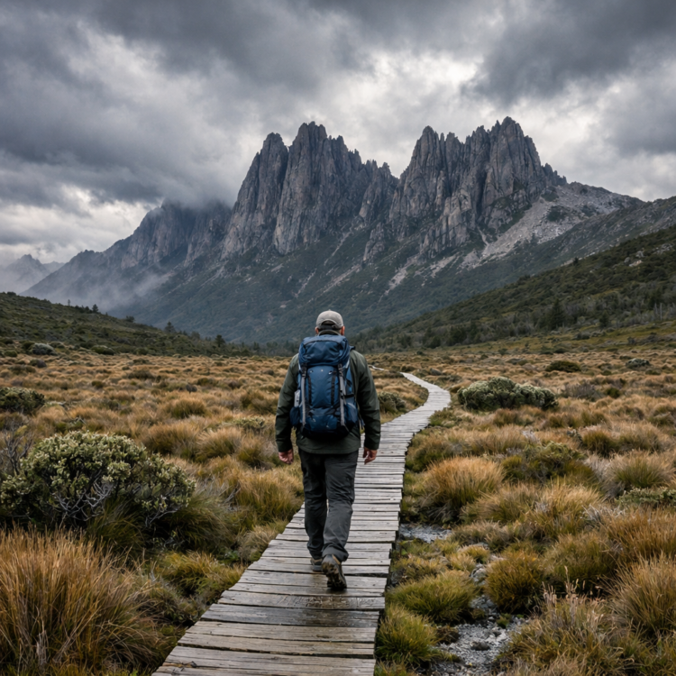
Hiking Tasmania’s Overland Track means committing to six days (sometimes five, occasionally seven) without a road, a shop, or a phone signal. This 65-kilometre trail runs north to south through the Tasmanian Wilderness World Heritage Area, from Cradle Mountain to Lake St Clair, and it’s the closest thing Australia has to a true backcountry pilgrimage.
Why the Overland Track Stands Apart from Other Tasmanian Walks
Tasmania has no shortage of wilderness tracks, but the Overland has earned its reputation as the island’s most iconic multi-day hike. You’re walking through buttongrass plains that stretch to jagged dolerite peaks, then dropping into cool temperate rainforest where myrtle beech and pandani crowd the trail. The landscape shifts daily.
Wildlife sightings are common. Wombats graze near the huts at dusk. You might spot a Bennett’s wallaby on the trail, and if you’re exceptionally lucky, a glimpse of a Tasmanian devil after dark—though they’re shy and rare. The birdlife is constant: black currawongs, green rosellas, and the occasional wedge-tailed eagle overhead.
When to Book Your Hiking Tasmania’s Overland Track Permit
The track operates on a booking system during peak season, which runs from late October through May. You’ll need a permit, and they sell out months in advance—sometimes within hours of release for popular dates in January and February. Book through the Parks and Wildlife Service website as soon as bookings open (usually in July for the following season).
Summer (December to February) offers the longest daylight and warmest temperatures, but Tasmania’s weather is famously fickle. You can experience four seasons in a single day, any month of the year. Autumn (March-April) brings fewer crowds and spectacular colour in the deciduous beech, though nights are colder.
Winter walking is technically possible but requires serious alpine experience. Snow blankets the higher sections, and some huts close entirely.
What Hiking the Overland Track Actually Involves
Most walkers take six days, staying in the Parks and Wildlife huts each night. These are basic shelters—timber platforms, a roof, a tank with untreated water (filter or purify it), and composting toilets outside. No mattresses, no heating, no cooking facilities beyond what you carry. You’ll need a tent as backup; huts can fill up, and bad weather sometimes forces walkers to stop short of their planned hut.
The daily distances aren’t huge—typically 10 to 16 kilometres—but the terrain is uneven, often muddy, and occasionally steep. The first day includes an optional side trip to the summit of Cradle Mountain itself (an extra four to five hours return), and it’s a scramble over massive boulders near the top. Worth it? Absolutely, if the weather cooperates and you have the energy.
Essential Gear You’ll Actually Need
- A lightweight tent (even though you’re hoping to stay in huts, you must carry one)
- Waterproof jacket and pants—not just showerproof; expect horizontal rain
- Warm layers: fleece, insulated jacket, thermal base layers
- Gaiters (the track is notorious for mud)
- Stove and fuel (no fires allowed on the track)
- Water filter or purification tablets
- Navigation: map, compass, and consider a GPS device or phone app with offline maps
- First aid kit and blister treatment
The Sections You’ll Remember Long After
Day three—Windermere Hut to Pelion Hut—crosses Pelion Plains, a vast buttongrass expanse ringed by mountains. On a clear day it’s sublime. When the mist rolls in, it’s eerie and otherworldly, the kind of landscape that feels prehistoric.
The side trip to Mount Ossa, Tasmania’s highest peak at 1,617 metres, splits off near Pelion Gap. It’s steep, rocky, and entirely optional, but standing on that summit with views across the Central Plateau rewards the climb.
The final stretch into Lake St Clair is long—nearly 18 kilometres if you walk the whole way. Most hikers arrange a ferry pickup from Narcissus Hut (check the ferry schedule and book ahead; it saves hours). Lake St Clair itself is Australia’s deepest natural freshwater lake, dark and still, hemmed in by forest.
Logistics: Getting There and Getting Back
The Overland Track is not a loop. You start at Cradle Mountain (north) and finish at Lake St Clair (south), so you’ll need transport at both ends. Commercial shuttle services and tour operators run between Launceston, Devonport, and the trailheads—check current operators and prices through the official visitor website. Some walkers arrange a hire car drop-off and pickup, but you’ll pay relocation fees.
Most people base themselves in Launceston or Devonport before and after the walk. Plan at least one buffer day; weather can delay your finish, and you don’t want to miss a flight home because of a storm on day five.
Is Hiking Tasmania’s Overland Track Right for You?
This isn’t a beginner’s first overnight hike. You need to be comfortable carrying a 15 to 20 kilogram pack for multiple days, navigating in poor visibility, and managing your own safety in remote country. That said, it’s not a technical mountaineering route—just a long, sometimes muddy, occasionally steep bushwalk through spectacular terrain.
If you’ve done multi-day hikes elsewhere and you’re prepared for changeable weather, the Overland rewards you with a kind of solitude that’s increasingly rare. You’ll walk for hours seeing nothing human except the trail under your boots. At night, if the clouds clear, the stars are sharp enough to cast shadows. That’s what keeps people coming back.
You might also like:
- Bondi to Coogee Walk at Sunrise: Why Dawn is the Best Time for Sydney’s Coastal Classic
- Night Walks in the Daintree Rainforest: A Guide to After-Dark Wildlife Spotting
For current opening hours, prices and bookings, see Australia.com (Tourism Australia) – Uluru & Kata Tjuta.
